BackgroundFollowing the devastating floods in the summer of 2007, the government instigated a comprehensive programme to overhaul our National Flood Risk Strategy. The programme was based on the recommendations of the Pitt Review (2008) in which a team led by Sir Michael Pitt evaluated the lessons learnt from the floods. Recommendations from this review were reflected in the national and local planning policy documents that have come into force since 2011.
Under the new planning laws, all proposals for new developments have to carry out flood risk assessments (FRA) which have to show that the development conforms to the following criteria:
The new houses will not flood.
The development will not worsen the risk of flooding elsewhere (for us this includes our neighbours on the Levels).
Any development on a greenfield site must not produce more run-off than the was produced before the development.
A sustainable drainage scheme (SuDS) must be produced to ensure this happens.
The Parish is producing a Flood Risk Guide for Planning Applicants. This will be a supporting document to the Neighjbourhood Plan. More details are here.
We have had a number of development applications that have made SuDS proposals as part of their flood risk assessments. Most of them take the form of ponds which temporarily retain run-off and then release it immediately at a gradual rate that does not exceed the 'normal' run-off rate of the site before development. This is usually done automatically by a device called a hydrobrake.
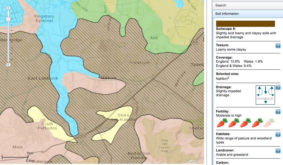
Government best practice advice suggests that developers should firstly maximise the amount of water falling on the site that soaks directly into it using devices like soakaways and porous hard surfaces. However, these are rather expensive and developers are allowed to avoid proposing them in areas where the soil is recorded as fairly heavy clay which is not very permeable and where there are no underground aquifers. This is technically the case for Martock according to the online database of soils that developers use. Because they use this they are spared the legal requirement to carry out fieldwork to determine the actual drainage characteristics of the site.
This is a debatable issue for many reasons on which the neighbourhood plan may comment:
Many of the soils around the village are, according to more detailed mapping, naturally permeable (see the map below). The run-off rate is normally close to zero unless some compression of the soil has occurred. This means that SuDS have to retain a lot of water.
Serious flooding on the Levels occurs when the ground there is saturated. To mitigate this we should have schemes that hold back as much run-off as possible for an extended period until it can be released safely into the Parrett. This would imply that ponds should be bigger and release mechanisms may have to be under the control of flood wardens.
We should insist on local fieldwork before the SuDS is designed as permeability seems to vary considerably throughout the village area (see map below).
The way the village is drained is complex and proposals should recognise this to avoid overloading any one part of it unnecessarily - particularly the small capacity Mill Brook.
The new SuDS should be fully integrated into the existing 'Hills to Levels' ongoing programme in the village and its environs that is designed to improve the flood resilience of the Levels.
The SuDs infrastructure will require maintenance. It is government policy that this should be planned as part of the planning application include who takes responsibility. It seldom is and could potentially be expensive.
The map below is from 'Soilscapes', an application run by Cranfield University which provides fine detail of soils on a contrywide map. The detail includes permeability. The cream, pink and hatched brown (Soilscape 8) described in the table on the right) are all relatively highly permeable. The blue areas are also permeable except when the water table is high making them at risk of flooding.
|
More information - click the links
On SuDS for the layman.
The definitive SuDS manual. All you need to know
Cranfield University 'Soilscape' app to explore the permeability of local soils (see map below as an example).
Technical stuff on SuDS including a tool to calculate the size of a SuDS retention pond for any given development.
The 1979 Water Street Flood
Thanks to everyone who contributed information and photographs of this event during the Bath and West Show time at the end of May 1979. The information allowed us to determine much about its likely cause. For more about this see the post on the comment page on this site.
|
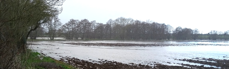 Flooding in the Parrett valley near Parrett Works, March 2016