Martock Neighbourhood Plan
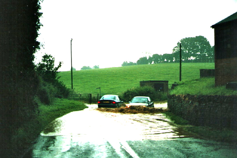
Floods across the road, approaching the bridge at Parrett Works, March 2016
Home - Local character - Natural Environment - Drainage - Flood guideFlood Risk Guide |
|
|---|---|
Why we need a Flood Risk Guide Martock has long been prone to flash flooding. This happens when flood water is unable to flow downstream into the River Parrett as fast as the water flows into the village from the hills to the south and east. The flow out of the village depends on a number of factors including the restrictions on flow at Frickers Bridge and Hurst Bow Bridge, together with flood control programmes downstream and also the tides and weather conditions in the Bristol Channel may also influence the flow out of the Parrett basin. Strategies to control the flow onto and across the Somerset Levels have greatly reduced the severity of the flood risk in recent years. This has resulted in a considerable reduction in the flood risk to property in Water Street including the shop shown in the photograph. A consequence of the reduced flood risk, however, is an increased tendency to build today in places that our ancestors tended to leave alone. |
Water Street flooded frequently in the past but mitigation measures put in place nearly four decades ago have made this kind flooding much less common. |
Who is the Guide for? The Guide is for anyone wishing to build in Martock. It seeks to provide information and evidence from a community perspective that will lead to safe, sensible and sustainable development and to the necessary action and mitigation that prevents flooding both in the village and in communities downstream. It provides local detail not readily available elsewhere; details of past flooding, details of current strategies, such as the 'Hills to levels' scheme of the Somerset Rivers Authority, to mitigate flooding both in the village and downstream and details of the considerable variation in permeability of the soils around the village. A particular and important local characteristic is that damaging floods in the village tend to be flash floods and are, in their extent and the area they affect are somewhat unpredictable. They are associated with saturated ground and a heavy burst of rain somewhere in the catchment but also often with tidal conditions in the Bristol Channel and the point in the local agricultural cycle when run-off is increased because the soil is temporarily compacted. Blocked or small drains and rhynes are also frequently associated with sudden floods. Another characteristic of such floods is that they not only rise quickly, they also drain away equally quickly. There is a strong focus in the Flood Guide on local prevention measures designed to minimise the damage caused by flash flooding and we expect developers to design drainage systems that reinforce these measures rather than create conditions that may impede them. |
The Flood Risk Guide can be downloaded here. Comments are sought and can be emailed to info@Martockplan.org.uk or via the contact page of this website |
Climate change Planning regulations require developers to make allowances for climate change. These regulations are couched in terms of allowing for increased rainfall rather in terms of an increased rate of rainfall. Our experience is that the latter is as significant as the former as factor which causes flooding in Martock. The result is that flood mitigation proposals often involve retention ponds designed to cope with a '1 in 100 year' storm event but which are inadequate for sudden storms–that may individually be quite short in duration–falling on saturated clay ground. We may then experience an 'excedence event' which, although quite short-lived, has the potential to cause flooding, when the drainage strategy for a development is overwhelmed and flood water flows uncontrolled downstream. We are advised by experts that (a) we should now expect so-called '100 year events' almost once a decade and (b) that we are likely to experience an increase in active energetic weather events which result in sudden storms that create run-off volumes that risk temporarily exceeding the capacity of the drainage systems. Flood Risk Assessments that we see in the village tend to promote strategies that address the former but not the latter. |
Climate change predicts an increase in the frequency and intensity of such events. The Flood Guide addresses this. |
How is the Martock Flood Guide being produced? The Flood guide is locally produced and will have the support of the Parish. It is being developed under the auspices of the Neighbourhood Plan Steering Committee by a small team concerned with floding in the Parish. They are: |
|
Village Consultation The First Operational Draft has been produced and can be downloaded here.. How to Comment: This will lead to a second draft which will be part of the package of Neighbourhood Plan supporting documents that will be subject to a formal 'pre-submission' consultation before they are put to the District Council for formal approval If you would like to receive monthly information on the progress of the Neighbourhood Plan and these supplementary documents please email info@martockplan.org.uk. |
|
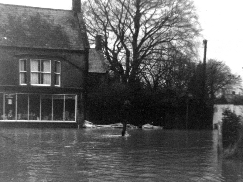 The hardware shop in Water Street (now Martock Gallery) in one of the quite frequent floods last century. Note the sandbags across the gateway to the house down the sloping drive behind.