Category Archives: Natural environment

The first Consultation Draft of the Plan

The first Consultation Draft of the Neighbourhood Plan is now complete. 

We have spent a year or so gathering data and opinions on all the aspects of the Plan. With the help of an expert we have built the first draft of a Plan based on all this. It is written to a standard planning format in several sections each about a different topic. Every section follows the same format;

1 An introduction arguing why plan policies are needed
2 Plan policies, usually in several topics within each section
3 An explanation and elaboration of how the policies will be applied.

You will probably see that there are many gaps, many areas that are not clear, and possibly some mistakes.  We need help to improve it.

Please help by going to the draft download page where you can download either the whole plan or a particular section that is of most interest.  Comments can be made by email to info@martockplan.co.uk, or via the contact page of this site.

Or you can publish your comment on any of the comment pages in the menu bar – click the ‘Leave a reply’ link.  Please allow day or so for publication (anti-spam)

Andrew Clegg

The great 1979 flood


Lots of interesting discussions and memories about floods at the Neighbourhood Plan Farmers’ Market stall last Saturday (10 June).

Particularly about the great flood of May 1979, which sounded like the biggest thing since Noah.

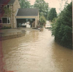
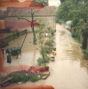
Thanks for all the memories and the photos. Pity there was no photo of the wheelbarrow that floated gently down Water Street outside the Ironmongers (now the Picture Gallery). Whose was it and what happened to it? Does anyone know?

The great thing about this flood is that we had the exact date (almost) because it was the Bath and West weekend where they had to tow parked cars out of the field with tractors. This probably put the flood on or around Thursday 31st May 1979. So I searched online and came up with a few details:

1 There is a flow gauge on the Parrett at Chiselborough. It measures the flow of water from its upper catchment area of about 30 square miles, only about 4% of the total flow down the river. It usually records about 42 cubic feet a second. On 30th May 1979 it recorded the highest ever flow rate of 6100 cubic feet/second. Thats about 150 times normal!

2 In May 1979 the Yeovilton weather station recorded the third wettest month ever with 171 mm (7 inches) for rain. The normal May fall is about 2 inches. I cant find on what days the rain fell but the records show that May 1979 was an odd month with quite a bit of snow the first week and a lot of rain at the end. It looks as though most of the 7 inches fell in the last week.

3 People told me that they had had quite a lot of continuous drizzle before the 30th and then one huge storm. This seems typical of floods here – a sharp storm falling on saturated ground.

4 The spring tide down at the Bridgewater end of the Parrett was on 26th May, just a few days earlier. This is important because it means that the sluice gates that stop the sea coming in (and the Parrett flowing out) will have been closed for longer than normal.

5 The sea level will have been even higher than a normal spring tide because of the low air pressure of the storm system coming in from the west. This means that the air presses down less on the sea so the sea level rises. By a surprising amount; about 1cm for a drop of 1 millibar. If the storm was as big as reported the sea level could have been 30 cm higher than normal just because of low air pressure.

6 Everyone reported that the water came from upstream rather suddenly. Rumour said that a sluice gate may have been opened for safety reasons upstream but nobody knew exactly where. What was clear from the accounts was that the water not only ran through the front doors but went quickly round the back and flooded kitchens as well. Presumably there was so much water downstream in the Parrett by then that it backed up so there was nowhere for the Martock water to go.

7 Then, in the afternoon it suddenly went down. Low tide at Bridgewater everyone agreed. And of course it is a low spring tide which is lower than normal.

8 The Environment Agency recorded a major Levels flood in June 1979. presumably in the first week of June.

Thanks again to everyone who left their memories and stories and photographs. They were all very useful. In the next post I will try and summarise the lessons learned from these that can translate into possible Neighbourhood Plan Policies.

Andrew Clegg

Footpaths – where people walk around Martock

Thanks to everyone who talked to us at the Farmer’s market on 8th April about where they like walking. Here is the map you completed

At this stage in the Neighbourhood Plan we are collecting and recording evidence. This suggests that the countryside around Martock is all equally valued and people use all the footpaths.

The Village Survey that was completed last month will give us more evidence that we will add to the map.

We also asked about how often people walk. Of the 34 responses, 18 reported daily, 11 weekly and 5 monthly.

Andrew Clegg

Views around Martock

Thanks to all who came to the Martock Neighbourhood Plan meeting last Saturday. Good to see so many.

Many people were very interested in the maps from the Martock Peripheral Landscape Study that we had on display. These showed where the important views are and where the finest landscapes are around the village. This is a very useful publication. It will help us plan where future housing and business development should, and should not, be.

The Landscape Study is now on the website, and can be downloaded, at http://www.martockplan.org.uk/Environment/Landscape.html.

It would be good to follow this up by building up a collection of pictures and descriptions of the parts of the Martock Landscape that you walk through and like.  The more contributions we have the easier it will be to protect the it and the views from it.

I live at Bower Hinton, just a short walk from the circle of low hills, Ringwell Hill, Hallett Hill and Cripple Hill.  From these we can see as far as the Mendips northwards and the Levels westwards.  The gap in the hedge below shows the back of Sparrows Works, the church tower in the centre and the Mendips not quite visible in the hazy distance

IMG_2919

Below is a landmark that is noted in the Landscape Study.  Almost every view looking south from Martock will have this row of oaks that mark the top of Hallett Hill.

IMG_2924


It would be good to build up a record of the places and views people like around the village.  Let us know here (click ‘leave a reply’ above) or upload pictures to the Martock Neighbourhood Plan Facebook Page

Andrew Clegg 15/3/16